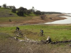
 Zon from MTBR had a vision, his vision was to circumnavigate Folsom Lake on Mountain Bike trails. This ride was the result of Zon’s Vision, I’m glad I was able to be a part of this ride for a lot of reasons. The ride was almost exactly 50 miles long, which is by a long shot a personal distance record for me. I have ridden 50 miles on a road ride before… but that doesn’t count. The total effort involved in this ride was many times that required on the road ride.
This ride had some unique challenges as well, primarily the fact that short of riding clear to Auburn there is no easy way across the long dogleg section where the North Fork American River enters the lake. The solution to this was a unique one, Zon arranged to shuttle us by boat. Anyhow… check out the pictures and my impressions of the ride here.
Great write up, 0gre!
Wow, that sounds really fun. I wish I could go on rides like that, but I don’t think my stamina can go that far. My personal best is around 25 miles. I hope you guys had a fun time.
I have been thinking and talking to alot of people about doing a similar sort of ride around the lake and trying to connect to Falconcrest Sweetwater and Salmon Falls from the town of Folsom (and the light rail station). The only trail map I have seen shows one or two horse only trails connecting Falconcrest with “Dyke 8” . In otherwords how do I get to the Sweetwater trail from the Town of Folsom?
If you are starting from Folsom you get onto the Dyke from Folsom point and ride across the Dyke to Dyke 8 trail which is some singletrack that starts at the east end of the Dyke. The legal singletrack ends at the Marina but I’ve been told the singletrack from the Marina to Falconcrest is ridden by mountain bikers all the time. Right around now it’s probably not the best ride due to tons of mud. After the mud dries out it’s a great trail all the way to Sweetwater.
I’ve updated the writeup to include the map Zon printed out for us. The section between Falcon Crest and the town of Folsom was a bit confusing and without trail markers from Zon would probably have been tough to follow with just the map.